14 September 2008

D is for distractions

"Ugh! What's that smell?" I thought as the bug-splattered nose of the Tacoma pointed towards Johnson Corner.

"Oh God! It's me!" Damn, I was rank. I had just dropped off a pair of hikers I came across on the Mt Princeton road. Given my cab was in disarray from gear tossed everywhere, the two hopped in the bed and held on for the bumpy ride down the 4-wheel-drive road. If my windows were open when I responded to their hitchhikers thumb, they probably would have jumped in the back given the foul odor I was emitting.

What could I expect? I was still wearing the same polypro I put on Saturday morning. When I woke up Sunday at camp, I thought, "Why get other clothes dirty since you'll be sweating 15 minutes after setting off?"

When I got back to the truck I thought it was as big of a folly now to put on the fresh set of clothes since I would be home in less than three hours.

Now, I would have gladly traded my soul for a clean pair of boxer shorts.

Option D

My sights were set on Crestone Needle when last week began. If I could scrounge up a partner, the route I wanted to take was the Ellingwood Ledges - a 50 Classic Climbs of North America route. If I went solo, then up the punter route, maybe swing over to the north buttress and do some 5th-class up the last few hundred feet, and if the weather held, do the exposed traverse up and over to Crestone Peak.

And then Thursday and Friday happened. It rained, and it rained, and if you were high enough up, it snowed. I knew from a pal who climbed the Ellingwood Ledges route, this wasn't a mountain you wanted to be on when wet.

So Friday night I went to sleep with the Gore Range dancing in my head. Saturday morning I woke up and looked out west and was dismayed. There was quite a bit of snow blanketing Mount Evans.

It wasn't the snow. It was there wasn't enough snow. There would be just enough to cover things, melt on Saturday and Sunday and make the two peaks I had in mind treacherous.

Well Option C was a return trip to Fruita, but I decided to keep that one in reserve for next month with a buddy.

And so Option D it was.

Welcome to Buena Vista.


Saturday was spent bouldering and firewood gathering. The bouldering, well, let's just say I have the crimping strength of a paraplegic Still the two sessions were good. The first one came to an unceremonious end of me jumping from 10 or so feet up and sprinting away in my climbing slippers. With my feet perched on tiny crimps I reached up to my next handhold, and when my fingers were a couple of inches from the pocket, four wasps exploded out like X-wing fighters on the Death Star trench run.

Pulling over the lip on this sitdown start took a while. Body tension and methodical movements let my pull off of two slaps and get my right foot up.


Purging away the negative vibes. The fire was a good one, lasting over three hours.


Sunday after a cappuccino and a chocolate chip scone (not even remotely as good as my mother's), I made my way up the Mt Princeton Road. Now I've been on worst roads - stuff where you feel more like you're rock crawling than driving. But this by far is the road I never, ever want to drive up again. It was as wide as your vehicle and as I slowly lurched up the miles at a blitzing speed around 12 mph, I kept praying nobody would be coming down, cuz there are maybe a handful of very narrow pullouts on the stretch.

View from my parking spot around 11k. The way up follows the left skyline.


Why? Why would I do another choss slog? Well, it seemed like something to distract me - and this was a weekend of much, much needed distraction. I started hiking up the road and finally reached the trailhead. Off I went. Not much blow-by-blow. It's a friggin hike on choss.

Looking back towards the east. You can see the ribbon of Hwy 285 leading back into the hills and into South Park - the flat wasteland in the distance.


Two hikers I'm about to lap. I stopped counting after 12. People move slow & I've spent a lot of alpine time this summer, what can I say?


Looking towards Mt Democrat, Independence Pass, et al
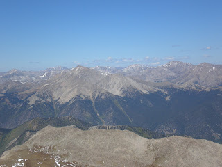


Looking towards Gunnison and Crested Butte.


Looking back towards Buena Vista and the craggy foothills where I slept Saturday night.


Yes those are headphones in my ears. iPod is one of the 10 essentials on this trip.


I made it up in less than 2 hours. I made it down in almost the same amount of time. Two hikers lost their companion who stopped 300 feet short of the summit. I found him slowly plodding down a ways down. I yelled at him to stop and wait where he was and then signaled up to his buddies, still high up on the ridge.

I saw three teens cutting down too quickly and getting themselves in some nasty talus slopes. Because I'm an idiot and still have some concern for fellow beings, I dropped down myself to make sure they were okay and then directed them out towards the trail. I'm becoming more mountain goat (sans horns) this summer and getting quite used to the talus balancing.

I was distracted, it was good. Now just need to make it through Monday.

08 September 2008

Working the brain & the body

Spent Saturday in an 8-hour workshop on web design. It felt good to use the old noodle geting a better feel on dip tags, tables, shortcuts and just a better concept at how to look at designing web pages.

Sunday was a day of no expectations. I ditched the Type A personality and just packed up a backpack with some extra layers, some food and headed out into the alpine. Was thinking the past week about how I'm always on the go; I never just enjoy myself in these areas as much as I should. It's usually about getting to Point B from Point A and then maybe ticking off Point C while I'm there.

So leaving the guidebook in the truck on the eastern shore of Brainard Lake, I started hiking down the road to the Long Lake Trailhead. To call this the Indian Peaks Wilderness Area is a misnomer. There wasn't enough parking space at the trailhead, hence the need for an extra 1 1/2 miles in each direction.

Things I learned:

* The trail is much easier than when Rak and I attempted Little Pawnee in not-quite-fall anymore but not-quite-winter yet conditions. It's much quicker to walk when the trail isn't coated with a sheet of ice.

* Listening to an iPod while passing the hoards of tourists helps numb out the chatter of the same people I try to escape when I visit such places.

* Brainard Lake is a fee area. Since this was my first visit to the area when the road wasn't gated, I had no idea or completely forgot. Thousand Trails, the private entity contracted out by USFS, charges $8. Say what?! I pulled up to the gate, told the lady to write me a ticket cuz I had no cash, other than the quarters I was saving up to give my truck a desperately-needed wash. I got away with handing her the $3 in change and was on my way with just a brief shrug of the shoulders.

At the west end of Long Lake I headed straight up through the downfall-festered forested slopes.

Only a few hundred hundred feet of this wasn't too bad:


Looking back where I started after bashing through the forest and onto the tundra slopes of the East Ridge of Little Pawnee. I'm parked at the far end of the lake in the distance.


Looking towards where I'm going. The point on the left is where Rak and I made it last November in icy, blustery conditions due to some nasty blisters on his heels. The point in the middle is Little Pawnee Peak. Peak on the right is Mt Toll.


Flora & fauna. A butterfly clings to some nectar as the winds begin blowing incessantly.


A quick note: once I got onto the steepening, narrowing ridge of Little Pawnee, the wind began whipping pretty bad. I went from T-shirt to adding my long-sleeve Patagonia layer, fleece vest and my liner gloves. Suffered through some ice cream-head moments too.

The trip was fun. I stayed on the ridge crest and had some great exposure, some fun climbing, some thoughtful climbing where you didn't want to knock a block off and send you the quick way down into the basin and some surprisingly-good sections of rock.

The highlight was going au chevel on one of the points with legs dangling into nothing on each side of the gendarme's edge.

Some shots of the ridge connecting to Pawnee Peak


I figured I climbed up to the summit of six different points. Truth is I had no idea which was the summit of Little Pawnee. It was when I felt I was doing some downclimbing for a while and came to the infamous notch on the East Ridge of Pawnee did it dawn on my that I already climbed to the top and was pleasantly completing the connection to Pawnee.

Did the 4th-class downclimb and climbed back up the other side. I'm not going to give away the beta since it was really fun doing the route finding. Sometimes you go to the south at some notches, other times to the north. And for the main notch, go to the north side and scramble down.

Summit pitch one one of the points. The funnest 5th-class I did all day.


Finally after a little more knife-edge traversing, I came to a point the fun ended. There was about 500 feet of talus slogging to the top of Pawnee. Hmmm... talus... yum. I still have a bad taste in my mouth and bruised toenails from my talus slog on Jasper Peak a couple of weeks ago.

So I did the ridge again in reverse. Much better to climb than slog. The wind was terrible on the ridge. Several times I had to huddle or climb to blocks on the leeward side to avoid getting pushed into the void. The worst was at the notch.

To show the effects of the wind and not how ugly I am. My hair is being whipped, my backpack has one strap hooked around my leg to avoid getting blown off and it was hard to breath as the wind actually pushed close my right nostril.


Traversed down the south side of the ridge from one of the points down steep talus. Almost went face first a couple of times and played Tip Cup with a giant block that levered against my right calf. To avoid a bad situation, I endured the cramping pain this block the size of me was inflicting on my leg until I could move out of its path before letting it go free. I was hopping for a dramatic accidental trundle. All I got was a 2-flip thud as it came to a stop.

Through some meadows and back to the Pawnee Pass highway. Headphones back in, I blurred past the masses on the way out. Ran into Rak and Ian coming up the trail by Long Lake. Talked for a bit and we agreed to meet at Southern Sun in Boulder for some well-deserved pints and dinner.

01 September 2008

Respite at last

Labor Day weekend couldn't come at a better time. After enduring four days of the DNC, the sojourn from controlled chaos was welcomed.

It began Thursday night. After Obama's acceptance speech - only a slight part was I able to watch due to making sure meltdown didn't happen with our post-speech coverage - Janet and I headed down to the CNN Grill. CNN rented out Brooklyn's Grill next to the Pepsi Center and used it as a studio, workspace and free advertisement during the DNC. I called my contact in Atlanta and got some passes in for myself and a few coworkers.

Really the blur reads CNN Grill in blinking lights. Really.


Audra, Robyn and Everett enjoy some much-deserved refreshments inside.


Friday at work was tedious. Tedious because after the long hours and the constant controlled - and some of a Gommorah scale - we all just wanted the week to be over with.

Saturday started with chores, housework, some shopping and a trail run. I noticed while driving to the trailhead that I still had a pair of climbing slippers in my truck. So I switched destinations and headed to my mountain home; Three Sisters. Would run up the trail to some boulders, switch into my slippers and climb. Repeat. Wish I remembered my chalk bag but got by just wiping my hands on the granite multiple times. Finally finished with several highballs.

Made a wrong sequence on this one and was glad I was pulling with my strong side - the right - to correct my mistake. 5.8 is fun and easy but you really feel it when you're 30 feet from the deck.


Saturday night went to Audra's birthday party downtown at a couple of places. A good time was had by all, especially the birthday girl.

Sunday woke up rather lethargic. Not hungover; didn't drink that much. Not sick, just bleh. My original agenda of backpacking into the Gore Range, setting up camp and climbing up Outpost Peak's south ridge, followed by a day on one of the Partners on Monday seemed tedious. Some days you just don't want to go uphill forever.

Instead rode the bike from my place down to Confluence Park, past that to Coors Field and Five Points and back home. A good 30-mile tour, nice and mellow and relatively flat. Sunday night was an early night of a few rounds with some friends.

Monday woke at 6 am. I intended to get up Pawnee and Little Pawnee and climb the 4th-class exposed knife-edge which connects the two. However it rained lightly at my place late Sunday night and Monday dawned with more clouds than I felt comfortable with; I'm still a little lightning-shy since last weekend.

So back to bed and out for some dirt-rash. I try to bike around Pine Valley Ranch at least once a year. The past couple I've been fortunate to have my buddy Jason join me, but today him and Sandi were making the down payment on a place for their wedding next year.

It's always a great fun ride but when you think about it, you can't help but think of the long uphill which marks the beginning. And when you're grueling at a very slow grind for what seems like eternity, I'll profess, it's nice to have somebody suffering along with you.

For some reason it wasn't as bad this time. Actually cut out about two stops that we'd usually take to catch our breath and decompress our calves and quads.

This spot marks the end of the constant uphill. Roughly 1,200 feet higher than the trailhead.


Rode really well actually. I remembered quickly the tricks of Buffalo Creek area riding. It gets fast and it gets loose and deep. Meaning there are innocuous stretches that will fishtail you out and dump you before you realize what happened. Also you can't brake while in those quagmired sections; that is a guarantee for a wipeout. You just have to remain alert.

The ramifications of the Buffalo Creek Fire are still readily evident more than a dozen years later.


At the end of the Skipper Trail, I took a right instead of heading back to the trailhead. A few miles up I took a break by some beefy boulders. The entire area is littered with giant granite boulders - many of them too sheer and devoid of imperfections for anybody to scale unless your last name happens to be Sharma or Graham or Nicole.


The ride back was exhilarating. Took on a couple sections I've wussed out on in the past. Discovered a new downed tree in the middle of the trail at the last section and not quite sure how I hopped over and avoided a nasty collision. Also a couple other sections of downhill I pleasantly surprised myself by staying in my saddle when coming across some technical difficulties which were thrown in at the last second around a curve.

A drive back to Conifer, a stop at Heidi's Deli for refueling and I was back to my mountain home again. Switched into my approach shoes which can get me up some good moderate stuff. Climbed up The Brothers for about the twelfth time. This time I played the game of you must climb everything in front of you. Started right at the trail junction and up a slab and a headwall, traverse over on a ridge, up another headwall to a slab (the nature of much of the climbing on this side of the formation). Several hundred feet of mid-fifth class - with a couple of highball headwalls in the 5.9+ range to season things up - interspersed with some easy scrambling.

Looking down the south side. There is a fun moderate route up just to the left of my feet.


Cut across the forest to my secret little saddle. It's an area which I find in harmony with. To me it's a perfect idyllic forest scene with a few rock outcrops to clamber up and contemplate.

Checked out a few rocks past that and climbed some more. Then my Platypus went dry. Back to civilization.